

Local Government Information Model - Types of Parcels
The Local Government Information Model used by the ESRI Parcel Fabric is described in detail in the "GIS and Land Records" book by Nancy Von Meyer (ISBN-13: 978-1589480773). This data model provides the most comprehensive data structure focussed on Land Records we have seen to date and we highly recommend this data model to everyone involved in mapping Land Records.
Although it originally was released in conjunction with the ArcMap Parcel Fabric, the data model is based upon sound Land Records data modeling principlesand is still the best, and most comprehensive data model available for creating and maintaining Land Records in GIS. Please take some time and explore the ways in swhich it categorizes the various elements of Land Records and ensures that all elements are properly stored with relevant attribution.

Two Distinct Classes of Information
Overall, the data model breaks information into two distinct categories: the information that serves to partition lands (Public and Private) and the various types of land ownership (Tax Parcels, Fee Simple Ownership, Encumbrances, and Separated Rights.)
I just wanted to inform you that the following discussion of the Public and Private divisions is not meant to be exhaustive or thorough. It is intended to introduce the concepts; additional information can be found here.
Information is split into discrete layers or "Types" of polygons within each of these classes.
Partitioning Classes
The Partitioning classes are divided between Federal Subdivisions of Public Lands, commonly referred to as the Public Lands Survey System (PLSS) or Rectangular Survey System, and Private Subdivisions in which private landowners divide their lands for sale to individuals.
Please note that I am purposely using the word "partitioning" instead of "subdivision" because there are so many meanings and implicit baggage that come along when we use the word "subdivision”. Recognize that the word "partition" is intended to define lands that are owned by an entity that is dividing up the lands so they may sell off portions of it to other individuals.
Federal Subdivisions of Public Lands
The polygon "Types" related to the Federal Partitions directly reflect the components of the Original Surveys from which the Federal lands were sold to private citizens through patents or deeds. These "Types" also reflect the order in which the lands are identified in many ways.
PLSS Townships

Type 1 polygons reflect the first division of Public lands from which all other divisions are derived. These "Townships", depending on the data of the survey and instruction provided to the original surveyors, may be anywhere from 6 miles square (the most common) to 7 miles square and several other variations. They are identified by their sequence from the Initial Point in the Principal Meridian. They are referenced in a North-South direction as lying North or South of the baseline and East or West of the Principal Meridian.
All measurements involved in the PLSS are performed using the "Gunter's Chain," generally equivalent to 66 feet in length.
PLSS First Divisions (Sections)
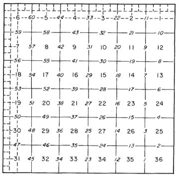
SECTION NUMBERING AND SEQUENCE IN WHICH SECTION LINES ARE SURVEYED TO SUBDIVIDE TOWNSHIPS
Type 2 polygons reflect the second division of Public lands into smaller polygons approximately one mile by one mile in size. The sections were constructed after establishing the Township perimeter and the original surveyor placed monuments at defined locations. They are numbered beginning with "one" at the northeast corner of the town and numbered sequentially in a snake pattern, alternating east to west and then southerly until all sections are identified. The "normal" section of land consists of approximately 640 acres.
PLSS Second Divisions (Quarter Sections, Government Lots)
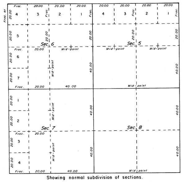
DIVISION OF SECTIONS INTO QUARTER SECTIONS
Type 3 polygons reflect the third division of Public lands into smaller polygons by connecting straight lines between the monuments established by the original surveyor at the sections' North, South, East, and West lines. These are commonly referenced as "Quarter Sections".. The goal of establishing these quarter sections was to create as many aliquot portions of land containing as close to 160 acres as possible. If, however, the sections measured longer or shorter on the northern or western tiers of sections with the Township, smaller aliquot portions are created. These aliquot portions include the Government Lots around sovereign lands, previous land grants before the acquisition of the lands by the US Government or other situations.
There is a general misunderstanding of his process within the mapping community that believes that quarter sections are derived by dividing the Section into fourths - This is incorrect.
PLSS Special Surveys

SPECIAL SURVEYS
Type 4 polygons reflect the fourth division of Public lands and encompass those situations in which special surveys were required. According to the BLM, these are nonrectangular components of the PLSS, including Meandered Water, Corners, and Conflicted Areas (known areas of gaps or overlaps between Townships or state boundaries).
Private Partitions
The next two polygons, "Types," describe the partitioning of lands by private landowners into smaller areas for sale to others. Because almost all lands in the United States are derived from the original public ownership managed by the Federal government, the exact location and definition of these private partitions (subdivisions) depend entirely on the quality of the location of the Public polygon types.
Simultaneous Conveyances (Subdivisions and Condominiums)

PRIVATE SUBDIVISION
Type 5 polygons reflect the overall extent of privately owned lands that are partitioned into groups of smaller lots of units for sale. As with the smaller divisions of the Public lands partitions, the smaller units of the Private partitions come into existence when these partitions (Subdivision Plats or Declarations of Condominiums) are approved and recorded in the public records. In other words, the smaller divisions are "simultaneously" approved and "conveyed" into existence. Since these units are created at precisely the same time, none of these smaller units are "senior" nor "junior" to the rights of any other units in the subdivision. These Type 5 polygons include those divisions commonly referred to as "Subdivisions" and "Condominiums".
Simultaneous Conveyance Divisions (Lots, Blocks and Units)
SUBDIVISION LOTS AND TRACT
Type 6 polygons reflect the final type within the Parcel Data Model that reflects the partitioning of land for sale and does not contain any information about land ownership. This polygon type is intended to contain the smaller divisions of land with the larger Type 5 polygons (Simultaneous Conveyances). If the larger Type 5 polygon is a traditional Subdivision, these smaller divisions might be lots, tracts, reserved areas, road tracts or parks. If the Type 5 polygons is a Condominium, these polygons may represent the individual unit boundaries, including its 3D space, limited common ownership, or general common ownership.
Ownership Types
The remaining polygon types within the Local Government Information Data Model cover the various ways in which land can be owned. The following discussion is not intended to be a treatise on land ownership in the United States, but a generalized discussion of how these ownerships are stored with the Parcel Data Model.

Ownership interests within the United States are not a single right but are often called a "Bundle of Rights." As such, one can possess a majority of the rights (often referred to as "fee simple ownership" or a single temporary or permanent right.
Right to Pay Taxes - Tax Parcels
The first ownership type stored in the Parcel Data Model is intended to store and manage information about the "right to pay taxes". This is the polygon type most often mapped and maintained by Property Appraisers (Assessors) offices throughout the country. One general public misconception equates these parcels to "ownership" of the parcels, without realizing these polygons represent the tax obligation or those properties on which ad valorum taxes are paid and may not represent true ownership. This is especially true when long-term lease interests contractually have been obligated to pay the taxes on these lands under lease (think shopping malls, etc.)
Fee Simple Ownership - Ownership Parcels
The Parcel Data Model's second ownership type and the eighth polygon type are intended to store and manage Fee Simple Ownership. Specifically, this is often used to map and maintain surface rights and neither subsurface rights such as minerals, gas, nor air space rights. While most agencies currently do not maintain information on these ownerships, I envision a time when it will become increasingly important.
Less than Fee Simple Ownership - Encumbrances
The next ownership type is that of Encumbrances. Black's Law defines encumbrances as the right of use over the property by another. In this sense, any use of the property by anyone other than the fee simple landowner can be considered an encumbrance. Encumbrances are often limitations of land use by the fee simple owner. Various encumbrances include rights of way or road easements, drainage or flowage easements, conservation easements, fishing easements, grazing rights, or utility easements.
Separated Rights
The next ownership type is that of Separated Rights. As noted in the Cadastral Data Content Standard for the National Spatial Data Infrastructure, separated rights are rights and interests in land ownership that can be disconnected from the primary or fee simple surface ownership. For example, mineral and oil rights are often separated from the surface ownership.
Other Rights
The final polygon type is intended to cover those other ownership interests that do not fit into any other polygon types.