
Let's take the three most consequential ones — the boundary accuracy assumption, the ownership completeness assumption, and the neutrality assumption — and actually follow each failure to its end.
If boundaries aren't where we think they are
This one is already wrong in a measurable way, and the consequences are already happening. They're just absorbed as "legal disputes" rather than recognized as a systematic data quality failure.
When a boundary is off by even a few feet, everything built on top of it inherits that error silently. A development permit gets issued for land that legally belongs to a neighbor. A tax assessment is calculated on the wrong acreage. An environmental impact zone misses a wetland by exactly the width of a mismapped boundary. Each of these looks like a one-off mistake. Systemically, they're the predictable output of treating precise-looking coordinates as ground truth when the underlying source documents were never that precise to begin with.
The deeper failure is that the error is invisible until someone litigates. The map looks authoritative. No confidence interval is displayed. A GIS analyst running a spatial query has no way of knowing that the boundary they're querying against has an effective uncertainty radius of 15 feet because it was digitized from a 1952 paper plat. The software presents the result with false certainty, and decisions get made on that certainty.
At scale — say, a city doing automated reassessment of 400,000 parcels — small systematic boundary errors compound into significant misallocations of tax burden, development rights, and infrastructure responsibility. The people most likely to successfully challenge those errors are the ones who can afford surveyors and lawyers. Everyone else absorbs the mistake.
If ownership isn't singular
The single OWNER field doesn't just simplify reality — it actively erases information that matters for almost every serious use of parcel data.
Consider what breaks. A city tries to identify all properties owned by a single corporate entity to investigate a landlord's code violations. The database has one owner per parcel. But the actual ownership is a chain: an LLC owns the building, a trust owns the LLC, a holding company owns the trust. The parcel map says "Elm Street Properties LLC." The investigator hits a wall. The data structure made the evasion easy.
Now scale that to infrastructure planning. A utility wants to know who to notify before trenching through a neighborhood. The parcel layer has names and addresses. But 30% of the affected parcels have easements that belong to other utilities, covenant restrictions held by a homeowners association, or deed restrictions running back to a 1940s subdivision agreement. None of that is in the OWNER field. The utility notifies the wrong people, misses the ones with actual rights, and discovers the conflicts only when someone shows up with a lawyer.
The most serious version: eminent domain and land acquisition for public projects. When a government needs to acquire land for a highway or transit line, it has a legal obligation to compensate all rights-holders, not just the surface owner. If the parcel database only knows about the surface owner, the process systematically underpays. The people most likely to be missed are holders of informal or customary rights — the ones whose interests were never formalized in the first place, often for historical reasons that connect directly back to assumption 3.
If the map isn't neutral
This is the assumption whose failure has the largest blast radius, because it doesn't just affect one decision — it propagates into every analysis that uses parcel data as a foundation.
Urban planners use parcel data to identify "underutilized land." But what counts as underutilized is defined by the map — and the map only recognizes uses that the formal system registered. Land that a community has farmed collectively for 80 years, without formal title, shows up as vacant or publicly owned. The "underutilization" finding is real within the data model. It doesn't correspond to reality on the ground.
Environmental justice analysis uses parcel data to identify who lives near hazardous sites. If the parcel layer has systematic gaps or errors in lower-income areas — which it does, because those areas were historically surveyed less carefully and updated less frequently — then the analysis underestimates exposure in exactly the communities facing the highest risk. The data gap and the harm gap overlap perfectly, and an analyst using the parcel layer as a neutral base will reproduce that overlap in their findings without ever knowing it happened.
The hardest version of this failure: indigenous land rights. In the US, Australia, Canada, and across former colonial territories, there exist legally recognized land rights — treaty rights, native title, aboriginal title — that are valid under the law but simply do not appear in the cadastre. A developer, a pipeline company, or a government agency that does due diligence using only the parcel layer will conclude there are no competing claims. That conclusion is not supported by the data. It is a gap in the data mistaken for an absence of claims. Litigation, project cancellation, and genuine harm to communities follow — not from bad intent, but from treating a political document as a complete record of legal reality.
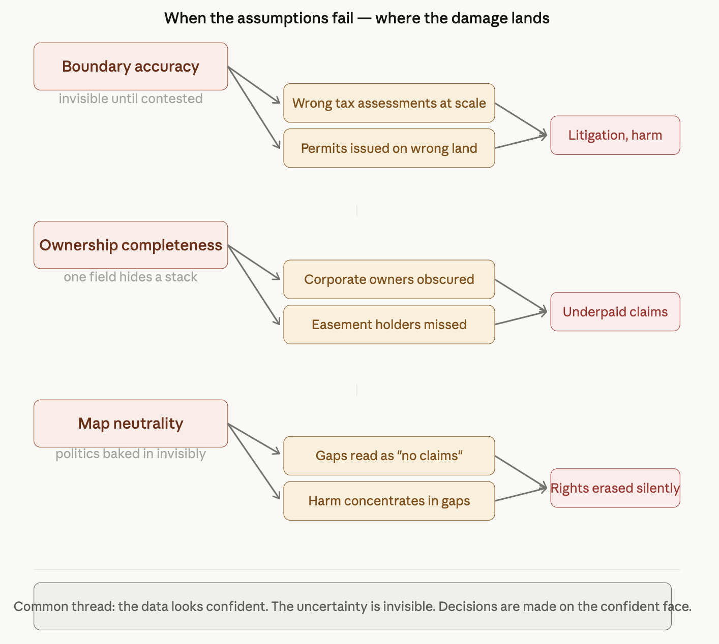
The thread connecting all three failures is the same: the data appears confident, and the uncertainty is invisible at the point of use. A map with clean lines, a database with filled fields, a spatial query that returns a crisp result — none of these signal "this is built on an assumption that may not hold." The analyst, the planner, the engineer, the judge — they see the output. They don't see what was quietly assumed to produce it.
This is what makes these failures harder to fix than ordinary data errors. An ordinary error looks like an error. These look like facts.