
Now that we have broken down parcels to their bare minimum, how should we begin thinking about them?
We established three bedrock facts: the earth has surface area, humans make agreements about who can use portions of it, and those agreements get written down. Everything else is up for grabs. So let's design from scratch.
The core object isn't a polygon. It's a claim.
The atom of the whole system is this: a claim is an assertion by a person or group that they have a specific right to use a specific portion of the earth, for a specific purpose, for a specific duration.
Notice what's in that definition and what isn't. There's no "owner." There's no single boundary line. There's no assumption that claims tile continuously. There's no assumption that one claim per place is the rule. The claim is the primitive. Everything else — geometry, identity, time, confidence — hangs off it.
A single location might have five simultaneous valid claims: a family's right to live there, a utility's right to run a pipe underneath, a neighbor's right of access across the corner, a government's right to tax it, and a conservation organization's right to prevent it being developed. In the current system, only one of those — the "ownership" claim — gets a polygon. The rest get buried in documents nobody queries. In the system we're building, all five are first-class objects.
The data model
Instead of one flat table of polygons, the foundation has four objects and one linking structure.
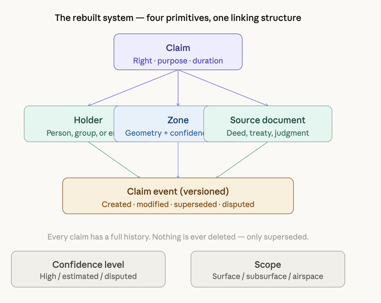
Four things every claim must carry, and two things the current system never tracks.
The two aspects the current system never tracks are confidence and scope. Every zone — every piece of geometry — gets an explicit confidence level: surveyed-and-verified, estimated-from-document, or disputed. You can't query this system without knowing how reliable the geometry you're querying against actually is. And every claim has an explicit scope: does it apply to the surface, the subsurface, the airspace, or some combination? A mine and a house can exist on the same ground-level polygon because they occupy different scopes. That's not a workaround — it's just accurate.
What replaces the boundary line
Instead of a line, every zone has an envelope: a most-likely geometry surrounded by a probability band representing where the true legal boundary might actually fall, given the uncertainty in the source document.
Think of it like weather forecasting. A weather map doesn't show you a single temperature — it shows you a gradient. Our boundaries work the same way. A freshly surveyed boundary with GPS monuments and a clean deed has a very tight band, maybe centimeters. A boundary derived from a 1890 metes-and-bounds description referencing a long-gone fence has a wide band, maybe meters. Both are represented honestly. Neither lies about its own reliability.
This means spatial queries change fundamentally. Instead of "does this point fall inside this parcel?" the query becomes "what is the probability that this point falls within this claimed zone, given the confidence of the boundary?" That sounds more complicated — and it is —, but it's honest, and honest is more useful than falsely precise.
What replaces the owner field
Nothing replaces it because the concept of a single owner has been retired. Instead, every location can be queried for its full claim stack: every right, every holder, every scope, every confidence level, all at once.
The query "who has rights here?" returns a list, not a name. Each item on the list says: this holder holds this right, with this confidence, from this source document, valid from this date, potentially expiring on this date, covering this vertical scope. A tax authority can filter for taxation rights. A utility can filter for subsurface access rights. A developer can filter for development restriction rights. They all query the same underlying data. Nobody gets a misleading single answer.
What replaces "the map."
The map in the current system is a display of polygons — one layer, one view, the implicit claim that this is what's real. In the rebuilt system, the map is a filtered view of claims, and the filter is always explicit.
You don't look at "the parcel map." You look at "surface ownership claims, high confidence only, as of today." Or "all claims of any type intersecting this flood zone, including disputed ones." The filter isn't a setting buried in a menu. It's part of the query, always visible, always part of the output metadata. Every map you produce tells you what it shows and what it doesn't.
This also means historical queries are native, not bolted on. Because every claim event is versioned and nothing is ever deleted, you can ask: what were the valid claims on this location in 1987? Who held subsurface rights here before the 1952 sale? When did this boundary shift, and why? The current system either can't answer these questions or does so poorly because it only stores the current state.
What the system knows, it doesn't know
This is the part that looks strange until you realize it's the most important feature.
The rebuilt system has a first-class object for gaps — zones where no claim has been registered, or where claims exist but haven't been brought into the formal system. A gap is not the same as unclaimed. A gap means "the system has no record here." That is a true statement. It's very different from "nobody has rights here," which is what the current system implies by showing you blank space.
Disputed zones are also first-class. Two claims that overlap and contradict each other don't resolve to whichever one got entered into the database first. They both exist, flagged as in conflict, until a resolution event (a court judgment, a negotiated agreement, a survey) supersedes one or both. Anyone querying that zone sees the dispute. Nobody gets to accidentally treat contested land as settled.
The honest summary of what we built
It's not a map system. It's a claims registry with a geographic interface.
The geometry serves the claims — not the other way around. The lines on screen are visualizations of legal agreements, displayed with their actual confidence, covering their actual scope, held by their actual full set of rights-holders, with their full history intact and their gaps honestly labeled.
What you lose: simplicity. One polygon, one owner, one clean map. That was easy to understand and easy to use. It was also wrong in ways that caused real harm.
What you gain: a system that knows what it knows, knows what it doesn't, and never mistakes the absence of a record for the absence of a right.