
First principles thinking means refusing to just trust what you've been told is true. Instead of accepting the way a field has always done things — its standard tools, its go-to answers, its unquestioned habits — you strip everything back to what you can actually prove yourself, and rebuild from there. The philosopher Descartes made this famous, but the instinct is older: if you can't verify something from scratch, you don't really know it — you've just borrowed someone else's conclusion. When you apply this to any technical subject, it means hunting down every hidden assumption, asking which ones are actually proven rather than just "how we've always done it," and being honest when the answer is that much of the foundation is shakier than it looked.
What this process changes isn't always the final answer — it's what you can see. Most inherited knowledge is genuinely useful. Experts compress decades of hard experience into tools and shortcuts, and those tools mostly work. But that compression hides things: the uncertainty, the edge cases, the political choices, the moments where someone made a judgment call and everyone downstream just accepted it. First principles analysis doesn't usually burn the whole field down. It shows you what the tools actually are, versus what they imply. The coordinate is still useful. The map is still useful. But now you know you're working with a model of reality, not reality itself — and that shift, from borrowed confidence to something you actually understand, is the whole point. At its core, it asks: What do we know to be absolutely true? From there, everything else must be rebuilt logically.
What “first principles” actually mean
The idea goes back to Aristotle, who described first principles as the fundamental building blocks of knowledge—things that cannot be deduced from anything else. In modern times, it’s often associated with innovators like Elon Musk, who popularized it as a way to rethink problems from the ground up.
Instead of thinking:
“How is this usually done?”
First principles thinking asks:
“What must be true, regardless of how it’s currently done?”
How First Principles analysis works (step-by-step)
Identify assumptions
Start by listing everything people believe about a problem—especially “that’s just how it works” thinking.Break the problem down
Deconstruct it into fundamental components or truths. These should be facts that don’t depend on convention.Challenge everything
Question whether each assumption is actually necessary or just historically accepted.Rebuild from the ground up
Construct a new understanding or solution based only on the fundamental truths.
Why it matters
In any field—especially technical ones like GIS, engineering, or data systems—complexity tends to grow over time. First principles thinking gives you a way to:
cut through that complexity
understand systems at a foundational level
and rebuild them in a clearer, more efficient way
It’s less about knowing more and more about thinking more clearly about what you already know.
Parcel Mapping in GIS: First Principles Reconstruction
Let’s start by examining the assumptions baked into how this works.
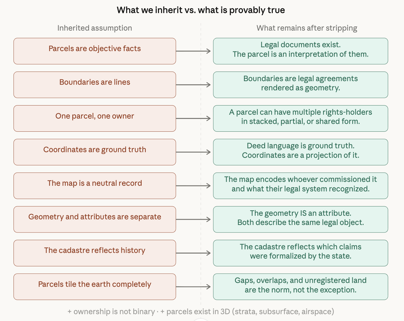
The Parcels Assumptions
Here are the inherited beliefs that almost everyone brings to parcel mapping, rarely examined:
Parcels are objective facts that exist in the world
The boundary of a parcel is a line
A parcel has one owner
Coordinates are the ground truth of location
The map is a neutral record of reality
Geometry and attribute data are separate concerns
The current cadastre reflects what actually happened historically
Parcels tile continuously — the earth is fully partitioned
Ownership is binary (you own it or you don't)
A parcel exists in 2D
Now let's strip each one and rebuild from what's actually true.
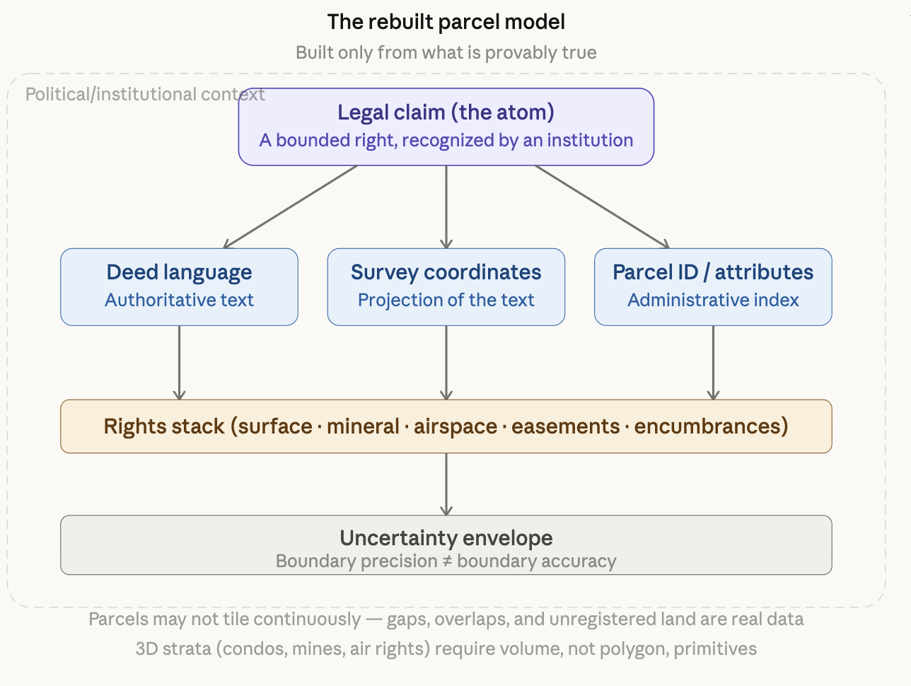
Now let's rebuild from the bedrock truths upward — what does the system look like when you build it from scratch rather than inheriting it?
The Rebuilt Model
The irreducible atom. Strip everything, and what actually exists is this: a legal claim, made by a human institution, about the right to use a bounded portion of the earth's surface. That's it. The geometry, the parcel ID, and the owner name — these are all representations of that claim. They are not the thing itself.
This immediately changes your data model. A parcel in GIS is not a polygon. It is a legal instrument that has a polygon as one of its representations. The polygon can be wrong. The deed cannot (legally). When they conflict, the deed wins — this is actual survey law in most jurisdictions.
What a boundary actually is. A boundary is not a line. A line is a model of an agreement. The agreement might reference a river (which moves), a fence (which was built by someone who guessed), a monument (which was placed, then disturbed, then replaced), or a verbal description that translates into ambiguous geometry. A GIS boundary drawn at sub-meter precision is often false precision layered on top of fundamentally imprecise source material.
The practical consequence: your spatial queries carry inherited legal uncertainty that the precision of your coordinates actively conceals. A 0.001° boundary looks authoritative on screen. It may correspond to a deed that says "to the old oak tree."
The ownership stack. One shape in a polygon layer implies one owner. But land rights are a stack — surface rights, mineral rights, airspace rights, easements, encumbrances, covenants, and future interests. The same geometry might simultaneously represent: full fee simple ownership of the surface, a utility's permanent easement through the southwest corner, a mineral company's subsurface extraction rights, and a covenant restricting what can be built.
Standard parcel GIS collapses this stack into a single polygon with a single OWNER field. That is not a simplification of reality. That is a different (and wrong) model of reality.
The cadastre is a political document. When you remove the assumption of neutrality, you see that parcel maps are the output of specific political processes. In the United States, the PLSS grid was drawn before most settlers arrived, carving land that indigenous people occupied into saleable units. Australia's cadastre contains parcels that overlap with legally valid native title claims but are not rendered in the same layer. Colonial cadastres in Africa drew boundaries through communities. The map didn't record reality — it created a new one by formalizing certain claims and erasing others.
This is not a peripheral observation. It means that using a cadastre as a neutral base layer for analysis systematically inherits the politics of who built it.
What Changes When You Remove Inherited Thinking
Your data architecture changes. The standard parcel layer is a flat polygon feature class: one row, one shape, one owner. The first-principles model requires at a minimum: a legal claims table (the atom), a geometry table (one-to-many: one claim, possibly multiple survey representations over time), a rights table (one-to-many: surface, subsurface, easements), and an uncertainty table (confidence intervals per boundary segment, not a single polygon edge).
Your query semantics change. "Who owns this parcel?" becomes "who holds which rights on this claim, as of what date, recognized by which institution?" That is not pedantry — it is the actual question that matters for taxation, development approvals, environmental review, and title insurance.
Your conflation of precision with accuracy breaks. GIS training consistently teaches coordinate precision as a proxy for data quality. First principles force you to track two separate things: the geometric precision of the coordinates, and the legal precision of the underlying boundary description. A boundary derived from a 1920 deed, transcribed with modern GPS coordinates, is high-precision but low-accuracy. Most cadastral data is exactly this.
Your base-layer assumptions become explicit. Using a parcel layer as a neutral analytical substrate — for demographic analysis, environmental modeling, infrastructure planning — carries the inherited politics of who built that cadastre and whose claims it recognizes. First-principles thinking doesn't say you shouldn't use the data; it says you should know what you're actually using.
Your temporal model changes. Parcels are not static. They are snapshots of a legal claim at a moment in time. A proper first-principles model is a temporally-versioned graph of claims — splits, merges, boundary adjustments, ownership transfers — not a flat layer with a last-updated date.
The Core Residue
After stripping everything, what's left that's actually, provably true is surprisingly spare: human institutions create bounded claims over portions of the earth, those claims change over time, and they stack in multiple dimensions. Everything else — the polygon, the parcel ID, the owner field, the cadastral layer — is infrastructure built to manage those claims at scale. GIS inherited that infrastructure without fully inheriting the epistemological humility it requires.