
Here are the five assumptions beginners absorb without questioning, with an honest verdict on each.
Here's the breakdown of each one.
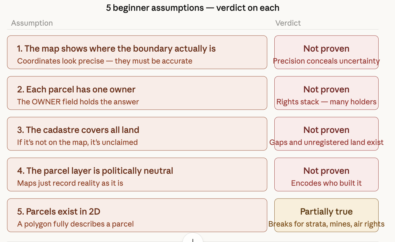
The map shows where the boundary actually is. Not proven. The line on screen looks like a fact. It's drawn with sub-meter coordinate precision. But that precision was produced by someone interpreting a document — often an old one, often vague. The document might describe a boundary using a fence post that's been moved, a creek that's shifted, or a tree that died in 1987. The coordinate is a confident-looking guess. Precision and accuracy are two completely different things, and GIS training conflates them constantly.
Each parcel has one owner. Not proven. The single OWNER field in every parcel dataset trains beginners to think ownership is a single, clean fact. In reality, the same polygon can simultaneously represent: a family's surface rights, a utility company's permanent easement through one corner, a bank's lien, a municipality's right-of-way claim, and a deed restriction that runs with the land forever. None of that appears in the attribute table. The map is showing you one slice of a layered legal object.
The cadastre covers all land. Not proven. In practice, parcel datasets have gaps — slivers between parcels where the geometry doesn't tile perfectly, roads that aren't parcels, public land that's registered differently, and in many parts of the world, large swaths of customary or indigenous land that was simply never brought into the formal registration system. Blank space on the map doesn't mean unclaimed. It often means "unclaimed by people the state recognized."
The parcel layer is politically neutral. Not proven, and this one has the most real-world consequences. Every cadastre reflects the decisions of whoever built it: which claims got formalized, whose boundaries got surveyed first, whose were ignored. The US Public Land Survey System carved up land before most settlers arrived. Colonial cadastres in Africa and Asia drew boundaries for administrative convenience. Modern parcel maps in many countries simply don't include indigenous land claims that are legally valid but were never registered. Using the parcel layer as a neutral base for analysis inherits all of that — silently.
Parcels exist in 2D. Partially true. For a single-family house on a flat lot, the polygon is a perfectly adequate model. The assumption breaks as soon as you have a condominium (your unit is one floor of a building; the polygon on the ground means nothing without the floor number), a mine (the valuable thing is underground), a telecommunications tower with a ground lease (the polygon is tiny; the real extent is vertical), or a historic air-rights deal over a railway (the "land" being sold is above the tracks). Most GIS software handles 2D parcels beautifully and 3D parcels awkwardly or not at all. Beginners don't learn that the tool was built for the easy case.
The only things that remain fully proven underneath all five: the earth has surface area, humans make agreements about who can use portions of it, and those agreements get written down. Everything else in parcel mapping is infrastructure built on top of that — useful infrastructure, but infrastructure that carries assumptions all the way down.