

AI, Parcel Mapping and Land Surveying - Will Artificial Intelligence Replace Parcel Mappers and Land Surveyors?
/Artificial intelligence has become the topic of nearly every professional conversation. It is writing software that generates artwork, answers technical questions, produces legal documents, and increasingly performs tasks once believed to require significant human expertise. It is only natural that professionals responsible for maintaining cadastral records and establishing land boundaries begin asking an important question:
Will artificial intelligence eventually replace parcel mappers and land surveyors?
The short answer is no—or at least not in the foreseeable future.
While AI will undoubtedly transform many aspects of our profession, the fundamental nature of boundary determination and parcel mapping depends upon something that artificial intelligence cannot easily replicate: the interpretation of imperfect evidence in the physical world.
The Difference Between Information and Evidence
Artificial intelligence excels when working with information that exists in digital form. It can analyze millions of documents, summarize legal opinions, extract text from deeds, identify patterns in parcel histories, and even assist in drafting legal descriptions.
Unfortunately, property boundaries are rarely determined solely from written information.
A deed may describe a property as running “to an old oak tree,” “along the centerline of the creek,” or “to the iron pipe set by John Smith in 1948.” The document itself provides only part of the story. The remainder exists on the ground, where physical evidence has weathered decades of change.
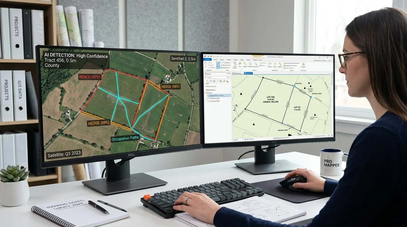
The true location of a boundary often depends upon evaluating monuments, occupation lines, fences, hedgerows, stone walls, roads, witness testimony, historical surveys, adjoining conveyances, and the actions of neighboring landowners. These are not merely pieces of information—they are pieces of evidence.
Evidence must be discovered, evaluated, weighed, and reconciled.
That process remains fundamentally human.
Boundary Resolution Is Not a Mathematical Exercise
Many people unfamiliar with surveying assume that determining a property boundary is simply a matter of mathematics.
If only it were that simple.
Modern software can compute coordinate geometry with extraordinary precision. AI can solve complex geometric problems almost instantly. Yet the greatest challenge in boundary retracement is rarely computing where a line should be.
The challenge is determining where the line was intended to be.
Legal intent often overrides mathematical precision. Original monuments frequently control over calculated positions. Senior rights may supersede later conveyances. Long-standing occupation may influence boundary location. Missing monuments require interpretation rather than calculation.
Artificial intelligence can perform the mathematics.
It cannot independently determine which evidence carries the greatest legal weight.
Every Parcel Is a Historical Investigation
One of the defining characteristics of cadastral work is that every parcel carries its own history.
A parcel created in 2025 may be relatively straightforward. However, we must also realize that all parcels are created from older, original parcels and the land interests established prior to their creation.
A parcel created in 1825 may involve:
Multiple deed transfers
Conflicting surveys
Road relocations
River movements
Lost monuments
Fence relocations
Easements
Adverse possession claims
Judicial decisions
Vacations and dedications
Boundary agreements
No two situations are identical.
Each requires professional judgment developed through years of experience studying boundary law, surveying principles, historical records, and local practices.
AI can certainly organize this information.
Determining what it all means is another matter entirely.
The Physical World Cannot Be Fully Digitized
Parcel mapping ultimately attempts to model a physical world that is far more complex than any database.
Even the most sophisticated GIS represents only our best and most recent interpretation of reality.
Artificial intelligence cannot walk through dense vegetation searching for a buried iron rod.
It cannot determine whether a fence has stood undisturbed for seventy years.
It cannot interview adjoining landowners about long-recognized occupation.
It cannot recognize subtle evidence visible only to someone standing on the property.
Nor can it replace the professional responsibility that comes with signing a survey.
Boundary surveying remains one of the few professions in which digital information must continually be reconciled with physical evidence.
Parcel Mapping Requires Judgment
Parcel mappers face similar challenges.
Contrary to popular belief, parcel mapping is not simply tracing deeds into GIS.
Every parcel map represents countless decisions involving:
Which document controls
How conflicting descriptions should be reconciled
Whether subdivisions supersede previous conveyances
How easements interact with ownership
Whether tax parcels differ from legal parcels
How to maintain historical parcel lineage
When geometry should reflect legal intent rather than measured coordinates
These decisions often require knowledge of local statutes, recording practices, historical mapping methods, and surveying principles.
Artificial intelligence may recommend possible interpretations.
The mapper remains responsible for selecting the correct one.
Where AI Will Make a Tremendous Difference
Although AI is unlikely to replace parcel professionals, it will almost certainly become an indispensable assistant.
Imagine AI capable of:
Reading thousands of deeds and extracting legal descriptions.
Identifying possible parent-child parcel relationships.
Suggesting subdivision lineage.
Comparing multiple legal descriptions for inconsistencies.
Detecting probable drafting errors.
Flagging parcels with conflicting acreage.
Summarizing title histories.
Identifying likely monument references.
Recommending adjoining documents for review.
Assisting in drafting parcel fabric edits.
Generating preliminary legal descriptions.
Automatically classifying recorded documents.
Searching historical map collections in seconds.
These are tasks that consume enormous amounts of professional time today.
Rather than replacing experts, AI will allow them to focus on the work requiring human judgment.
Professional Judgment Cannot Be Automated
The defining characteristic of both land surveyors and parcel mappers is not their ability to calculate geometry.
Software has performed calculations for decades.
The defining characteristic is professional judgment.
Professional judgment is built upon experience, education, ethics, and accountability.
It requires understanding not only what the evidence says, but why it exists and how courts have historically interpreted similar situations.
Artificial intelligence does not bear legal responsibility.
It cannot testify in court.
It cannot sign a survey.
It cannot assume liability for an incorrect boundary determination.
Ultimately, someone must make the final decision.
That responsibility belongs to licensed professionals and experienced parcel managers.
The Future Is Collaboration, Not Replacement
History suggests that technology rarely eliminates professions built upon expert judgment.
Instead, it changes the nature of the work.
Calculators did not replace engineers.
Computer-aided drafting did not replace architects.
GIS did not replace surveyors.
Likewise, artificial intelligence will not eliminate parcel mapping or land surveying.
Instead, it will automate repetitive tasks, accelerate research, reduce clerical effort, and help professionals analyze far more information than ever before.
The profession will evolve from spending countless hours searching for information toward spending more time interpreting it.
The Human Element Remains Essential
Land ownership is one of society’s oldest and most important legal institutions. Property boundaries define ownership, taxation, development, public infrastructure, environmental stewardship, and individual rights. Because of the legal and societal significance of those boundaries, determining their location has never been a purely technical exercise.
Artificial intelligence will undoubtedly become one of the most powerful tools ever introduced into the surveying and parcel mapping professions. It will improve efficiency, reduce repetitive work, and reveal insights hidden within vast collections of deeds, plats, and historical records. But the final determination of a boundary will continue to depend on professional judgment, legal interpretation, and the careful evaluation of physical evidence.
The future of parcel mapping is therefore not one where artificial intelligence replaces surveyors and parcel mappers. It is one in which experienced professionals leverage AI to become even more capable, allowing technology to handle routine tasks while humans remain responsible for the decisions that ultimately define the limits of land ownership.